Site-Heritage City, Gurgaon
Heritage City is an old residential complex on the main MG Road. After observing the residential area,it was found that even though other public/open areas in Heritage City are active and used by the residents, one particular area between the residential blocks 18,21,14 and 17 remains unused. This was the site chosen for analysis.
1. Comparing the site selected with other public areas in Heritage City.

1. Comparing the site selected with other public areas in Heritage City.

Heritage City Plan
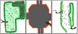
The black squares represent the areas being compared.

The three public areas.
Analysis-
The first image is that of a field used by children to play a number of games. The second image is the chosen site for study and the third shows another open area in heritage where a lot of social interaction is seen.
Function, Material-Both these active public areas have different functions. While the first one is used by kids and teenagers to play,the second one is used by young adults and adults to walk around, sit and chat also showing that a public area does not necessarily have to be a green area.
Scale-In terms of scale, the chosen site is the largest and has a very uncomfortable scale compared to the other two which are smaller thus being more habitable.
Accessibility- Though the two active areas can be accessed by people easily, the chosen site lies between four buildings which have their entrances from the opposite direction.
Elements on Site- The first area is essentially being used as a playground for kids. The other active area can be used to sit and interact on the seating/shade provided or to walk around. The site chosen however has concrete flooring and no specific shade/ places to sit.
2. Site Map
Scale- 1:100

Analysis-
The site map shows a rigid pattern being formed by the shape of the buildings and other elements existing on site.
2. Site Section
Scale-1:100

Analysis-
The site section shows the vertical height difference between a person in the open area and the four buildings around making it a very intimidating and uncomfortable space.
The open area is also directly visible from balconies running around the four buildings which also makes it less habitable and friendly to be in. The vertical scale difference must thus be broken for this space to be a more usable one.
3.Diagram showing the function, general mapping of people in the area.
Scale- 1:100

Analysis-
The area essentially has no specific function.A number of cars are parked around the area.
The pink patterns show the heated parts of the area. People are found in these two areas mainly because they're shaded. These existing parking skylights, cars and planters take up only about 20-30% of the area, leaving the rest of it still unused. The huge horizontal scale of the area thus needs to be broken too, to make it comfortable and usable.
4. Diagram showing view, accessibility and observed movement pattern.
Scale- 1:100

Analysis-
Even though this site is accessible from a number of ways, it only functions as a thoroughfare for people. The existing elements on site also reinforce this and create and particular pattern in which people walk in/around the area. This area can also be viewed at all times by the balconies of these buildings and thus the feeling of being in this huge space is that of being under a spotlight every second.
A flash mob was conducted in this open area to try to activate the space. This however had no significant impact due to the existing problems of scale in the area. The flash mob :
http://urbangorillazz.blogspot.com/2010/10/heritage-city-flash-mob.html
http://urbangorillazz.blogspot.com/2010/10/heritage-city-flash-mob.html
Aayushi Malik
II-A
No comments:
Post a Comment